101.7 FM

88.1HD2
 8.85 c
101.7 FM
88.1HD2

Time to evacuate is running out as Hurricane Milton closes in on Florida
BY The Associated Press, Oct 9, 2024 5:01 PM - REPORT AN ERROR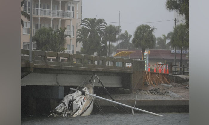
The serviceposted a photoon the social platform X of the funnel crossing the highway Wednesday morning with the words: “TORNADO crossing I-75 as we speak! Seek shelter NOW!(Photo: The Canadian Press)
A tornado crossed Interstate 75 in Florida as Hurricane Milton approached the state, the National Weather Service in Miami said on social media.
The serviceposted a photoon the social platform X of the funnel crossing the highway Wednesday morning with the words: “TORNADO crossing I-75 as we speak! Seek shelter NOW!”
Steady rain fell and winds began to gust in the Tampa Bay area Wednesday morning as a mightyHurricane Miltonchurned towarda potentially catastrophic collisionwith the west coast of Florida, where some residents insisted they would stay even after millions were ordered to evacuate. Stragglers face grim odds of surviving, officials said.
The Tampa Bay region, home to more than 3.3 million people, hasn't seen a direct hit from a major hurricane in more than a century. Milton fluctuated between categories 4 and 5as it approached,but regardless of the distinction in wind speeds, the National Hurricane Center said, it would be a major and extremely dangerous storm when its center makes landfall late Wednesday or early Thursday.
“This is it, folks,” said Cathie Perkins, emergency management director in Pinellas County, which sits on the peninsula that forms Tampa Bay. “Those of you who were punched during Hurricane Helene, this is going to be a knockout. You need to get out, and you need to get out now.”
Major bridges around Tampa Bay planned to close in the afternoon, she said, and public shelters were open for evacuees. Residents should not feel relief because of indications Milton's center might come ashore south of Tampa, she said.
“Everybody in Tampa Bay should assume we are going to be ground zero,” she said.
The normally busy interstate leading into downtown Tampa was mostly free of vehicles early Wednesday. Few cars moved on side streets. Drivers hoping to top off tanks were hard-pressed to find stations that weren't closed or boarded up. Many had plastic-wrapped their fuel pumps to keep nozzles from whipping around in hurricane-force winds.
In Hillsborough County, where Tampa is located, Sheriff Chad Chronister urged residents in a Facebook video to finalize their plans: “My message is simple. We’re approaching that 11th hour. If you need to get someplace safe for whatever reason, the time to do so is now."
Milton was centered about 230 miles (365 kilometers) southwest of Tampa on Wednesday morning, with maximum sustained winds of 155 mph (250 kph), just 2 mph (3 kph) shy of Category 5 status, the hurricane center reported. It was moving northeast at 16 mph (26 kph) and was expected to continue moving in that direction with an increase in its forward speed through Wednesday night.
In Charlotte Harbor, about two blocks from the water, clouds swirled and winds gusted as Josh Parks packed his Kia sedan with clothes and other belongings Wednesday morning. Two weeks ago, Helene’s surge brought about 5 feet of water to the neighborhood, and its streets remain filled with waterlogged furniture, torn-out drywall and other debris.
Parks, an auto technician, planned to flee to his daughter’s home inland and said his roommate already left.
“I told her to pack like you aren’t coming back,” he said.
Milton targets communitiesstill reeling two weeks afterHeleneflooded streets and homes in western Florida along its devastating march that left at least 230 dead across the South. In many places along the coast, municipalities raced to collect and dispose of debris before Milton's winds and storm surge — projected to reach as high as 12 feet (3.6 meters) in Tampa Bay and up to 15 feet (4.5 meters) farther south, between Sarasota and Fort Myers — could toss it around and compound any damage.
Heavy rain began to spread across parts of southern Florida on Wednesday, with conditions expected to deteriorate throughout the day, the center said. Six to 12 inches (15 to 31 centimeters) of rain, with up to 18 inches (46 centimeters) in some places, was expected well inland, bringing the risk ofcatastrophic flooding.Tornadoes were also forecast.
The storm is expected to retain hurricane strength as it crosses central Florida on Thursday toward the Atlantic Ocean. The precise track remained uncertain, but as of Wednesday morning, Milton's center was expected to make landfall somewhere around Tampa Bay. The highest storm surge is expected to occur at and south of the landfall location, the hurricane center said.
Sarasota County Emergency Management Chief Sandra Tapfumaneyi said that 11 emergency shelters were open there and that pets were welcome. Warning that this would be an “intense disaster” for the county, she urged people living on boats and in mobile and manufactured homes to leave: "We don’t want you staying in those structures. They will not do well in this storm with the high winds."
Tapfumaneyi also urgently warned people who live near bodies of water to leave immediately. Those areas saw flooding from Hurricane Debby last year and in 2022 from Hurricane Ian. She warned that the surge would travel up from the shore into rivers and creeks “on the path of least resistance.”
Authorities have issued mandatory evacuation orders across 11 Florida counties with a combined population of about 5.9 million people. Officials warned that anyone staying behind must fend for themselves, with first responders not expected to risk their lives attempting rescues at the height of the storm.


Share on
Related News


Sign up for the newsletter
We'll deliver best of entertainment right into your inboxWe love to hear from our listeners, so feel free to send us message

Message us on whatsapp


